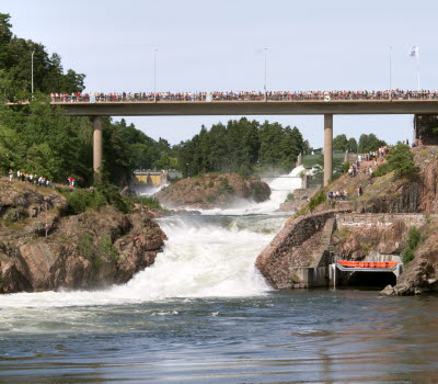
Trollhättan City Trail
Trollhättan
The Trollhättan City Trail offers a thrilling adventure starting at Hansenplatsen. This scenic route takes runners through a diverse landscape, from breathtaking viewpoints to mysterious forests and both historic and modern locks. The trail is elegantly framed by the serene beauty of the Göta River.
Quick facts
Length: 10.5 kilometers
Hiking time: About two and a half hours
Difficulty: Moderate
Terrain: Nature paths in uneaven terrain, high stairs, asfalt roads and gravel/dirt roads.
Embark on a adventure close by the city center
Start your journey along the Trollhättan City Trail from Hansenplatsen at Åkersbergsvägen. Cross the charming Strömkarlsbron bridge, featuring the iconic Strömkarlen statue, a local twist on the mythical Näcken. Ascend the stairs to the left and step into the enchanting realm of the Älvrummet nature reserve. Follow the empty riverbed and pass by the beautiful Oscarsbron bridge.
After approximately 2.5 kilometers of hiking, you'll reach Kopparklinten, offering the best view in Trollhättan. Take a moment to soak in the panoramic cityscape and the majestic Göta River, framed by the lush greenery of Älvrummet. The trail then leads you through a deep forest before turning onto Kärlekens stig, a scenic path that follows the Göta River all the way down to the Trollhättan locks area.
Photographer: BildIT
Trollhättan locks and canal
Take the time to explore more of Trollhättan's locks area. The Trollhättan City Trail passes by three generations of locks. Begin your adventure at the oldest locks, dating back to 1800 and 1844. As you progress, you'll encounter the more modern locks from 1916.
Turn north and go back through the exciting Träbrostigen trail, which winds through the deep, enchanted forests of eastern Älvrummet. As you emerge from the forest, you'll reach the impressive Olidan hydropower station. Conquer the challenging staircase that leads you alongside the station, a true test of endurance. Continue your journey past the Energihuset Insikten and follow the road back towards Oscarsbron.
Arriving back at the waterfalls area, climb the stairs, cross Åkersbergsvägen and continue along the charming pathways that wind between the canals, carrying water to the hydroelectric power plants. Turn left at Malgöbron, and you'll find yourself back at the starting point: Åkersbergsvägen and Hansenplatsen. Congratulations on completing your adventure!
Photographer: Roger Lärk
About the Trollhättan City Trail race
The Trollhättan City Trail is a cross-country race in central Trollhättan that started in 2016 and has become a part of Trollhättan Action Week, held every August. The race is a total of 10.5 km long and takes place on challenging trails and heart-pumping stairs (1040 steps in total). Along the way, participants pass several sights such as Kopparklinten, Gamle dal, Trollhättan locks, the Olidan power station, and Kungsgrottan. The Trollhättan City Trail is a race for those who love speed, excitement, and adrenaline or simply love running in beautiful nature.
Fact about the trail
Length:
The Trollhättan City Trail has a total length of 10.5 kilometers.
Approximate times:
Hiking the Trollhättan City Trail takes about 2.5 hours.
Marking:
Black square sign with the name and logo of the Trollhättan City Trail in white.
Level of difficulty:
The Trollhättan City Trail traverses very varied terrain with both nature trails and paved roads, and also with partially high elevation differences. There are also high stairs along the route. The trail therefore has a moderate difficulty classification.
Start and end:
Start your hike or run at the same place where the Trollhättan City Trail starts, along Åkersbergsvägen at Hansenplatsen heading north. The finish line is also at the same place, so you will return where you started after completing the race. There are black and white signs along the route showing the way.
How to get here:
To reach the start of the Trollhättan City Trail from central Trollhättan, you only need to cross the Klaffbron bridge at the Scandic Swania hotel. Then turn left over Malgöbron and continue down Åkersbergsvägen for about 130 meters, then start by turning left and crossing Strömkarlsbron. The starting point is only about 500 meters from Drottningtorget in central Trollhättan.
Map:
A digital map of the trail can be found on Google Maps.
You can also see the map of the Trollhättan City Trail on the race's website. You can download a GPX file of the trail here.


