De Laval's walk
Trollhättan
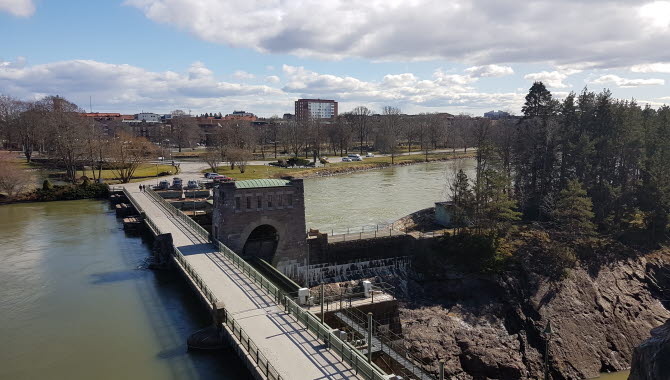
Discover Trollhättan Waterfalls area and see exciting history mixed with magnificent nature. The walk takes you both up to wooded heights with a view of the empty riverbed but also along the mighty Oscarsbron bridge and Åkersbergsvägen street where the water is always close.
Length: 1.60 km
Time required: 25 minutes
Difficulty: medium
Terrain: Nature trails with uneven terrain, smooth paved road
Walk around Trollhättan Waterfalls
Nothing has affected the history of Trollhättan as much as the Trollhättan Waterfalls. Here the first industries grew up and it was due to the waterfalls that the Trollhätte canal and locks were designed to allow shipping to pass safely during its journey south towards Gothenburg or north towards Lake Vänern.
Today, the falls no longer thunder continuously as they did before, but the water is released at specific times during the summer (due to the ongoing energy crisis there will be no release of water in the falls during summer 2023 except from during the Fallens Dagar (Waterfall Days) festival 21-23 July. To see current dates and times visit this page.
Even if there is no water in the riverbed, you are offered a fantastic view of the area and there are many exciting places to discover along the way. Start your walk at Hansenplatsen monument and begin by walking over Strömkarlsbron bridge, adorned with the statue Strömkarlen, the local version of Näcken (Neck – water spirit) which deep down is a friendly figure but who punished those who came to the city to cause mischief.
Then go up the stairs and follow the nature trail. There are viewpoints and areas with benches and tables if you want to sit down for a while. Then go down the stairs and cross the Oscarsbron bridge and see how the Göta River continues south after the waterfalls, you also see the nature reserve Älvrummet that follows the water. Walk past Hojum's hydroelectric power station and Trollhättan's church where you turn left and follow Åkersbergsvägen street back.
A swedish "fika" (coffee) with the best view
During the walk along the falls, there are several places where you can sit down and spend time overlooking the area. There are three places with a benche and table if you want to sit down and have a coffee. Look out over the riverbed, the water in the canal and just beyond this view you can glimpse the houses in the city center. In the riverbed you can also see the ruins of the ancient industries that used the power of water. Here were, among other things, mills, sawmills and other things.
Today, the water is used to supply the two hydroelectric power stations Hojum and Olidan, you can also see the upper part of the Hojum station on the other side from the Oscarsbron brigde.
Photographer: VisitTV
Feel the wing beats of history around every corner
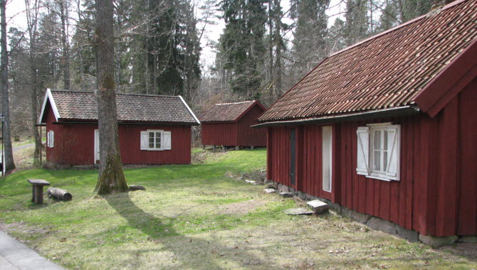
For those interested in history, De Laval's walk is an exciting experience, here are several places with great historical importance for Trollhättan. Among other things, you will see Ekeblad's lock, the first of the attempts made to let the boat traffic get past Trollhätte Waterfalls, which unfortunately failed. A small detour from the walk you will also find Forngården, an open-air museum where houses from old Trollhättan have been collected. A must is also to visit Kungsgrottan (the King's cave), Trollhättan's own autograph book where royalty have carved their names since King Adolf Fredrik in 1754.
All places of interest along the road are listed on the map.
Who was Gustaf de Laval
Gustaf de Laval (1845-1913) was a Swedish civil engineer, doctor of philosophy, inventor and industrialist who was one of the 19th century's most productive inventors in Sweden. During his life, Gustaf de Laval devoted himself to many projects, including in Trollhättan, where he created industries that were technically interesting but at the same time extremely electricity-intensive. For example, in the 1890s he built a factory to produce carbide electrically, an continuous working electrical arc furnace, a cyclone furnace for the production of zinc from poor lead zinc ores and more.
Fact about the trail
Length:
The walk is a total of about 1.60 km long.
Approximate times:
At a leisurely pace, the walk takes about 25 minutes.
Marking:
The marking is a shorter metal sign with an arrow and the name of the walk.
Level of difficulty:
The walk along the empty riverbed includes uneven terrain in a forest environment and a couple of high stairs. When you then come to Oscarsbron bridge and further on Åkersbergsvägen street, the walk is on a smooth paved road. Due to the uneven terrain at the riverbed, the hike has a medium degree of difficulty.
Start and end:
The walk starts right at the eastern end of Strömkarlsbron bridge, near the Hansenplatsen monument. Here is a sign describing the area. If you follow the whole walk, you will return to the same starting point again.
How to get here:
The Hansenplatsen monument on Åkersbergsvägen street is only about 500 meters from the Drottningtorget square in the center of Trollhättan. In other words, it is easy to get here by foot from the city center, but if you want to take the car, there is short-term parking at the Hansenplatsen monument. Parking disc required.
Map:
You can see a digital map of de Laval's walk on Google Maps here.
There is also a printed map that you can pick up at Trollhättan's tourist office or download as a PDF here.
Innovatum Science Center
Åkerssjövägen 16
461 53 Trollhättan
Phone: +46 520 289 400
E-mail: Send e-mail
Website: innovatum.se/


